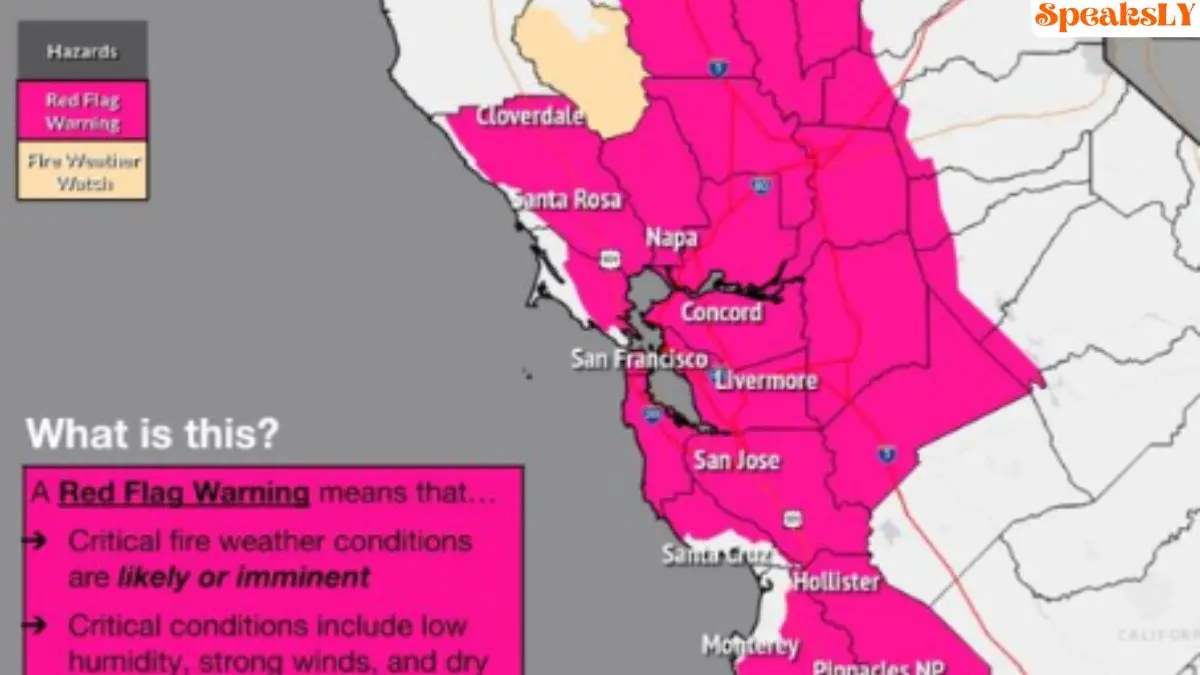
Red Flag (Fire Weather) Warning: The National Weather Service (NWS) has issued a Red Flag Warning for much of the Bay Area, effective from Thursday night through Saturday evening, as dry and windy conditions increase the risk of rapid wildfire spread. This elevated fire danger follows a Fire Weather Watch that was initially announced earlier this week but has since been upgraded due to worsening weather forecasts.
Key Details of the Red Flag Warning
The Red Flag Warning will be in effect from 11 p.m. Thursday (October 19) to 5 p.m. Saturday (October 21). Winds are expected to be a significant factor, with sustained speeds between 25-35 mph and isolated gusts reaching up to 65 mph at higher elevations, particularly in areas like the North Bay interior mountains, East Bay hills, Diablo Range, and parts of the San Francisco Peninsula.
Humidity and Fuel Concerns
In addition to the high winds, humidity levels are predicted to drop as low as 10%, creating an ideal environment for wildfires to ignite and spread. Although recent cooler temperatures had kept fuels relatively moist, this offshore wind event is expected to rapidly dry out vegetation, exacerbating the fire risk across the region.
The warning covers all nine Bay Area counties, including San Francisco, Alameda, Contra Costa, Napa, Solano, Sonoma, and surrounding areas. The NWS advises residents to prepare for potential fire outbreaks and to avoid any outdoor burning during this period.
PG&E Plans Potential Power Shutoffs
In response to the elevated fire risk, Pacific Gas & Electric (PG&E) is considering Public Safety Power Shutoffs (PSPS) in several counties, including Alameda, Contra Costa, Napa, Solano, and Sonoma. These preventive shutoffs aim to reduce the chances of power lines sparking wildfires in areas most vulnerable to the dry and windy conditions.
PG&E is actively monitoring the situation, and updates regarding power shutoffs will be available on their PSPS website. Residents in affected areas are encouraged to prepare for potential outages and ensure they have a plan in place for emergency situations.
Forecasters Warn of Dangerous Conditions
The NWS has also highlighted the risk of large wind gusts, particularly late Thursday into Friday, which could make firefighting efforts more challenging. “Despite recent cool weather and high humidity, we are expecting a widespread and prolonged offshore wind event, which will likely dry fuels out very quickly given their volatility over the past several weeks,” the NWS stated.
Beach Hazards Also in Effect
In addition to the Red Flag Warning, a Beach Hazards Statement is in place for parts of the San Francisco coast, North Bay, and Monterey Bay areas through Wednesday evening. Large waves could sweep across the shores unexpectedly, posing a risk to beachgoers.
Safety Precautions for Residents
Officials urge residents to stay informed, follow local fire updates, and prepare emergency plans. With high winds, low humidity, and dry fuels, the Bay Area is facing an elevated fire danger, and residents should take all necessary precautions. Make sure to have emergency kits ready, sign up for local alerts, and avoid any outdoor activities that could spark a fire.